Key details
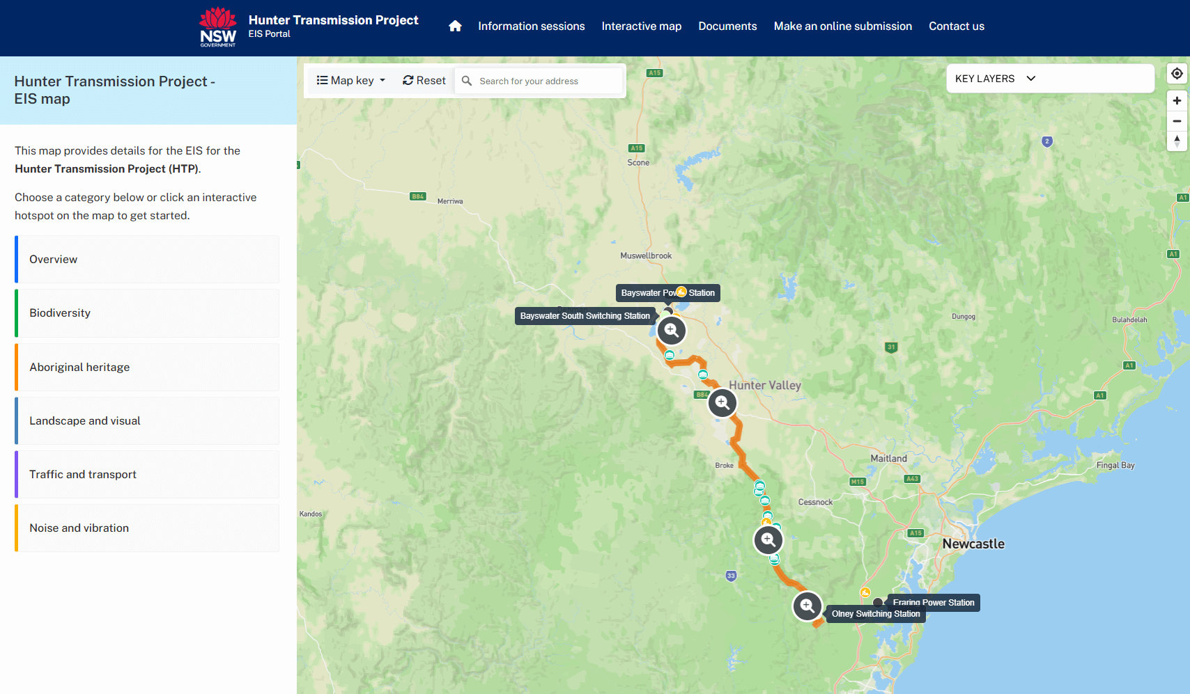
The Hunter Transmission Project (HTP) will help fix a missing link in NSW’s electricity network and connect renewable energy to homes and businesses across the State. A 110-kilometre transmission line will run from Bayswater in the Upper Hunter to Olney in the Lower Hunter. It will be built in a corridor of land, also known as an easement.
The corridor has been shaped by community feedback, consultation and technical studies, with refinement ongoing through the project’s environmental impact statement (EIS).
You can explore the corridor at key planning stages using the interactive map – including the preliminary corridor (Nov 2023), revised corridor (May 2024) refined corridor (Dec 2024), and the current corridor.
Keep up to date
Register to receive the latest project information and announcements including updates and opportunities to get involved.
-
Preliminary corridor
We identified a preferred Hunter Transmission Project corridor that balances land uses and minimises impacts. As part of early consultation, we shared the preliminary corridor for stakeholder feedback.
-
Investigation and refinement
We refined the corridor, focusing on minimising impacts wherever possible. We’re conducting detailed environmental assessments of the corridor as part of the planning and approvals process.
-
Preferred corridor
The preferred corridor is outlined in the project’s environmental impact statement (EIS).
About the Hunter Transmission Project corridor
We’ve chosen a corridor for the Hunter Transmission Project that seeks to avoid or minimise impacts on people and the environment, striking a reasonable balance between different land uses in the Hunter.
To achieve this, the Hunter Transmission Project corridor runs mostly though mining, energy and government land between Bayswater and Broke. It then heads into the Pokolbin, Corrabare, Watagan and Olney State forests where it joins the existing 500 kV transmission line running between Eraring and Kemps Creek in Western Sydney.
HTP corridor at a glance
- Best option to cause the least impacts on people and the environment
- Fastest way to deliver the Hunter Transmission Project and increase energy security
- Over 89% of the Hunter Transmission Project will be on mining, energy and government land
- Avoids most of the Hunter community, including major towns, villages and tourist areas
- Reflects changes that reduce impacts on biodiversity, Aboriginal cultural heritage and recreation
- Avoids Werakata National Park and Watagans National Park
- Avoids the Pokolbin wine/tourist area and other strategic agricultural land
- Minimises the impact on scenic landscapes
In a region as diverse as the Hunter it is difficult to find a suitable route between Bayswater and Eraring. To guide this search, we developed strategic principles for the project:
- maximise the use of power station and mine-owned land, suitable public land and existing transmission easements
- minimise significant land use conflicts and impacts on people and the environment
- minimise hazards and risks
- build community support
- deliver the project on time at a reasonable cost to consumers.
We started by identifying strategic corridors – broad areas where the new transmission line could be built. These corridors needed to:
- connect the existing electricity network at Bayswater and Eraring
- avoid towns, sensitive environments and critical industry areas
- follow existing infrastructure and public land where possible.
We divided the area into three broad corridors – northern, central and southern. Two of these corridors (northern and central) were quickly rejected due to significant land conflicts and impacts on urban areas, especially between Singleton and Newcastle. Using the northern corridor would also involve building a much longer and more expensive transmission line. This led us to examine multiple options in the southern corridor, which offered fewer community and environmental risks.

After rejecting the northern and central corridors, we focused on the southern corridor. This area offered fewer impacts to communities and the environment. Using our strategic objectives, we carefully assessed and rejected a number of alternative options.
The existing 330 kV transmission easement between Bayswater and Richmond Vale
The existing 330kV transmission lines are essential for supplying electricity to Newcastle. If we were to upgrade the existing transmission lines, we wouldn't be able to ensure energy reliability for Newcastle during this period. Once the new HTP corridor is built, we may look to upgrade the existing transmission line to 500kv to further unlock clean, affordable and reliable energy security in the Hunter.
Next to the existing 330 kV transmission easement
This option would cause significant land use conflicts in the Pokolbin wine/tourist area. It would also cause extensive clearing of endangered valley floor vegetation. This includes the Warkworth Sands Woodland and Central Hunter Valley Eucalyptus Forest and Woodland in areas such as the Singleton Military Area, Werakata State Conservation Area (SCA) and Werakata National Park.
The bushland to the south of the Pokolbin wine/tourist area
This option would result in even greater clearing of endangered valley floor vegetation in the Werakata SCA and Werakata National Park. This vegetation provides critical habitat for several threatened species such as the Swift Parrot and Regent Honeyeater. This option would also cause significant landscape-wide visual impacts in the rural-residential areas around Ellalong and Quorrobolong.
The valley further south of the Pokolbin wine/tourist area
This option would result in significant land use conflicts with the growing residential areas around Millfield and Mount View. It would also cause significant landscape-wide visual impacts in the rural-residential areas around Ellalong and Quorrobolong.
Existing 132 kV transmission easement
This infrastructure remains in use and the easements aren’t big enough to accommodate a new 500 kV transmission line. To use them we’d need to clear significantly more endangered vegetation, affect significantly more private properties and build part of the new connecting transmission line through the Sugarloaf State Conservation Area.
We selected the preliminary corridor as the best option for balancing the project’s needs with the need to protect the environment and local communities.
This corridor was chosen as the best option because it:
- avoids disruption to critical existing 330 kV lines
- impacts the fewest landowners
- steers clear of major towns like Singleton, Cessnock, and Maitland, and villages like Broke, Millfield, and Ellalong
- avoids national parks and critical industry areas, including the Pokolbin wine and tourism region
- makes significant use of public land in state forests
- minimises impacts to threatened vegetation and biodiversity
- maximises the use of mining and power station land.
We placed the Hunter Transmission Project preliminary corridor on public exhibition in late 2023. This was an opportunity for all stakeholders to offer their unique feedback and insights into where the new transmission line could be built.
You can read more about the preliminary corridor in our Hunter Transmission Project Overview.
By listening to and responding to local views, suggestions and knowledge, we revised the corridor to further minimise impacts on people and on the environment.
In May 2024, we presented the updated corridor to the community and submitted it as part of the project’s scoping report, which marked the start of the planning and approvals process.
We made significant changes to the Hunter Transmission Project corridor, including:
- reducing the number of potentially affected private landowners in the revised corridor from 78 (in the preliminary corridor) to fewer than 20.
- moving the proposed substation from Eraring to a former timber plantation site in the Olney State Forest to reduce the impacts on the Cooranbong and Martinsville communities.
- avoiding or minimising impacts in parts of the State forests that are culturally significant for the Aboriginal community and traditional owners, including scenic landscapes and and sightlines.
- pushing it the corridor further west in the Pokolbin and Corrabare State forests to reduce vegetation clearing and avoid impacts on threatened plants and animals such as the sooty owl, brush-tailed rock wallaby and scrub turpentine (a critically endangered tree).
These and other changes are described in Shaping the Hunter Transmission Project, our community update report from May 2024.
In December 2024, we shared the refined corridor with the community. The updated corridor reflects feedback from landowners and stakeholders, along with findings from technical studies and field work.
We made adjustments in several areas to help reduce impacts on people, land use and the environment. This includes shifting the corridor south of the Hunter Valley Operations mine expansion and further east of Mount Thorley to accommodate mining operations and potential flooding risks. We also made small adjustments in Pokolbin, Corrabare and Olney State forests, and on nearby private land. In many cases this was to avoid or minimise potential impacts to plants and animals.
The corridor will continue to be assessed and refined based on the findings of technical studies for the environmental impact statement (EIS) and as we continue consulting with the community about ways to further minimise impacts.
Learn more in our December 2024 community update report, Refining the Hunter Transmission Project.
The environmental impact statement is a comprehensive report that provides information on the economic, environmental and social impacts of the project. It helps the community, government agencies and the relevant ministers make informed submissions or decisions on the project. The Hunter Transmission Project needs approval from both the NSW Government and Australian Government before it can go ahead.
You can follow the Hunter Transmission Project’s progress and view all planning documents on the NSW Planning Portal, or visit the HTP Information Portal.
The corridor selection process leads to a final corridor of land called an easement. Construction of the Hunter Transmission Project will take place within a 140 metre-wide easement. After construction, this will be reduced to a permanent easement of around 70 metres for operation and maintenance.
The exact alignment of the transmission line including the location of towers will be confirmed during the detailed design phase. During construction, tower locations may be adjusted to respond to site conditions, engineering requirements and construction methods.
Frequently asked questions
The existing easements are inadequate to carry the large volume of electricity needed to meet growing demand in NSW. They are already in use and essential for the current electricity supply.
Upgrading the existing network would require lengthy system outages during construction which would have a major impact on the operation of the National Electricity Market (NEM). Expanding existing corridors would also cause significant environmental impacts and impacts on landowners and communities.
Most of the Hunter Transmission Project corridor runs through mining, industrial and government land but some private land will be needed to host the transmission infrastructure. Through corridor refinements, we’ve reduced the number of affected private landowners from 78 (in the preliminary corridor) to fewer than 20.
We’re also working with a number of landowners to acquire access easements (for access tracks) or construction leases (for laydown areas, intersection upgrades and road widening). We’re engaging with the affected landholders to identify concerns and minimise impacts where possible.
Overhead transmission lines are faster to build, cost less and have lower environmental impacts. They also offer higher capacity and fewer construction challenges compared to underground lines.
Underground transmission lines would not be suitable to install in steep terrain and require extensive excavation, which would create significantly higher environmental impacts. Underground lines also limit land use more than overhead lines and make fault finding and repairs more difficult, leading to longer power outages and extended disruptions to the supply.
The exact alignment of the transmission line including the location of towers will be confirmed during the detailed design phase. During construction, tower locations may be adjusted to respond to site conditions, engineering requirements and construction methods.
Consultation updates
Our reports keep the community informed with detailed updates at key stages of the project.
Browse our library of reports, fact sheets and project updates.
Visit the information portal for the Hunter Transmission Project.
An update on project developments, including refinements to the Hunter Transmission Project corridor and next steps.
Sharing the revised Hunter Transmission Project corridor, shaped by early community feedback.
Introducing the Hunter Transmission Project to the community and inviting early feedback on the preliminary corridor.
Learn more about the Hunter Transmission Project
Get in touch with the HTP community team
Phone us on 1800 645 972 (9am to 5pm, Monday to Friday)
Get in touch with EnergyCo
1800 118 894 (9am to 5pm, Monday to Friday)
Sign up for our Powering NSW e-newsletter.