About the REZ network infrastructure project
The New England REZ was formally declared by the Minister for Energy under section 19(1) of the Electricity Infrastructure Investment Act 2020 (the Act) and published in the NSW Gazette on 17 December 2021. View the Renewable Energy Zone (New England) Declaration Order (PDF, 28.9 MB).
The declaration was the first step in formalising the REZ under the Act and establishes EnergyCo as the Infrastructure Planner responsible for coordinating its development. It also set out the intended network capacity (size), geographical area (location) and infrastructure that will make up the REZ, and enables and sets the scope of key legislative functions under the Act, including access schemes and REZ network solutions (referred to in the Act as 'REZ network infrastructure projects'). As Infrastructure Planner, EnergyCo will make decisions such as assessing and recommending REZ network infrastructure projects.
The declaration followed an assessment of feedback received during the draft declaration exhibition period from 15 October to 12 November 2021. Minor adjustments to the geographical area were made which took both community and proponent feedback into account. These amendments improved the delineation between areas captured within the REZ subject to potential future development, and adjacent areas of National Park and World Heritage significance.
A stylised map of the specified geographical area of the REZ (PDF, 364 KB) is included for reference and accessibility purposes only. This stylised map does not form part of the declaration. The stylised map includes the existing 132 kV and 330 kV transmission infrastructure near and in the REZ as a geographical reference. You can download the GIS file of the New England REZ geographical area boundaryy (ZIP, 166 KB).
Note: The Minister in future may amend the declaration to expand the specified geographical area of the REZ, increase the intended network capacity, specify additional generation, storage and network infrastructure, provide further details and specifications, or correct a minor error.
A range of factors were considered in planning and identification of the five REZs, including:
- potential land uses impacts, including on agricultural land,
- environmental and social values, such as unique and sensitive biodiversity and cultural values,
- population and housing density,
- the location and availability of high-quality wind and solar resources, and
- distance to existing high voltage transmission lines.
The New England REZ has an intended network capacity of up to 8 gigawatts, aligning with the Australian Energy Market Operator’s (AEMO's) 2020 Integrated System Plan (ISP).
We received 80 registrations of interest for the New England REZ, representing 34 gigawatts of new energy generation and storage projects, during 2021. This interest significantly exceeds the amount of energy required to deliver the REZ. It will therefore help to ensure a competitive tender process and drive improved outcomes for the community.
For more information, visit Renewable energy generation projects.
EnergyCo is the Infrastructure Planner for the New England REZ and is responsible for the planning and development of transmission infrastructure required for the REZ. This includes all aspects of the environmental planning and approvals process, as well as the acquisition of any private land and easements needed for the project.
The delivery and operation of the network will be managed by the appointed Network Operator. EnergyCo will lead a competitive process to appoint the Network Operator which will design, build, finance, operate and maintain the new transmission infrastructure in the REZ. The successful Network Operator will then work with EnergyCo on the rollout of the project.
Given the substantial complexities involved in transmission infrastructure planning, there are specific national, state, and regional planning processes enacted that guide, revise and modify projects towards a final design.
Typically, such projects move from a ‘preliminary’ study corridor to a ‘revised’ corridor, and then to a ‘reference design’ corridor which forms the basis of an environmental impact statement (EIS) that is lodged with the relevant approving authority.
EnergyCo will be the proponent of the EIS for the REZ network infrastructure.
The EIS is expected to be displayed for public exhibition in the second half of 2026. All submissions received as part of the exhibition will be reviewed, and a response will be made publicly available in a Submissions Report.
While the planning approval processes and construction of the generation projects will be the responsibility of the developers, EnergyCo will have a critical role in coordination to ensure the impacts and opportunities for the community are considered as a whole.
Transmission infrastructure
The planning of the REZ Network Infrastructure is currently in the preliminary assessment phase, incorporating the conduct of studies and option analysis considerations. At a high level, the scope of the New England REZ infrastructure includes:
- new transmission lines connecting Bayswater Power Station near Muswellbrook to the REZ (dual 500kV lines),
- new energy hubs,
- new transmission lines within the REZ, and
- connection to new generation projects.
Energy hubs are a modern type of substation that act as a connection point between renewable energy projects and the broader transmission network. Energy hubs collect electricity from solar, wind and storage projects and transfer it to the network so it can be distributed to the homes, businesses and essential services that need it. More information is available in our energy hub fact sheet.
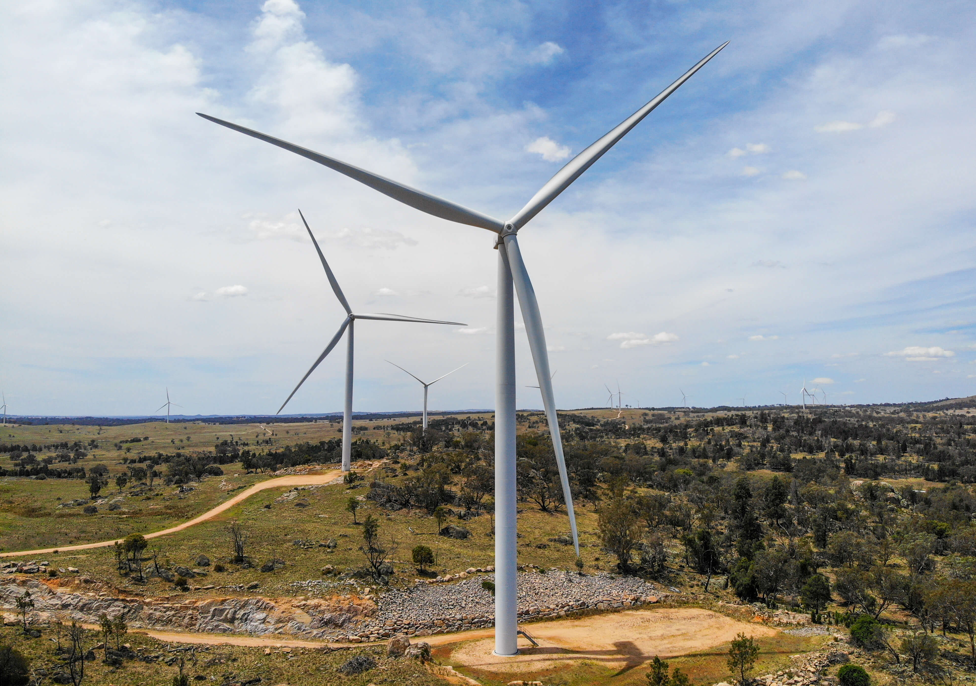
High voltage transmission lines will transfer renewable energy from the New England REZ to electricity consumers, with the ‘backbone’ of the new network expected to be rated up to 500 kilovolts (kV).
The towers will be up to 70 metres high and are generally spaced 400 to 600 metres apart. The transmission lines have a minimum clearance of 7.5 metres off the ground to allow farming and other activities to take place safely underneath.
These transmission lines will be located within easements 70 to 80 metres wide and may be co-located within a single easement or be physically separated. Easements will be wider where transmission lines are co-located.

EnergyCo is committed to delivering a safe, reliable and efficient transmission network for the REZ. We understand there is concern in the community about potential health impacts from electric and magnetic fields (EMFs) when living and working near transmission lines.
EMFs are found everywhere, including in the natural environment, and are produced wherever electricity or electrical equipment is used. According to health authorities, including the World Health Organisation (WHO) and the Australian Radiation Protection and Nuclear Safety Agency (APRANSA), EMFs from electrical transmission lines are not considered a risk to human health.
A detailed assessment of EMFs from the REZ transmission project will be carried out as part of the project’s environmental impact statement (EIS).
This assessment will ensure EMFs from transmission infrastructure, including energy hubs and transmission lines, are within the required guidelines. For more information, you can view our EMF fact sheet.
Route selection process
Major infrastructure projects follow a comprehensive and structured development process with the level of detail and assessment increasing at each stage. The early stages are broad and strategic which help us decide where the project could go. Later stages become more detailed to refine the project’s location and decide exactly how it will be built.
We are following a typical route selection process for a project of this size including option assessment through to final design – each stage increasing investigations and validation.
We constantly refine the corridor along the way to balance technical, environmental, social, and economic factors and importantly, make sure we meet energisation targets.
We welcome feedback from landowners and local communities on the preferred study corridor. We will continue to engage with potential hosts in or near the study corridor so their feedback can be considered in our planning process.
There will continue to be formal opportunities for the community to have their say via one-on-one meetings, online engagement, community drop-in sessions, community briefings, emails and phone calls. This feedback will be considered in the design and development of the project.
We understand that agricultural activities are essential to our State as well as the livelihood of communities in the New England region and will aim to minimise impacts to these activities wherever possible.
The final transmission alignment, including a 250m-wide corridor, will be presented in the environmental impact statement which is planned to be displayed for public exhibition in the second half of 2026.
The existing 330kV transmission lines that currently transfer power between Bayswater, Tamworth and Armidale, and between Armidale, Kempsey and Newcastle, are operated by Transgrid. The lines are running at near full capacity and are not suitable for the large amounts of energy to be transferred for the New England REZ. Even if the REZ operated at a reduced capacity, these lines would be insufficient.
Transgrid lines 83, 84 and 88 between Bayswater and Tamworth and 85 and 86 between Tamworth and Kentucky are 330kV single circuit lines. The New England REZ network infrastructure project needs to provide 6 GW of new network capacity through the first two stages, which requires four circuits at 500 kV voltage in addition to the existing lines.
EnergyCo considered whether the existing lines could be upgraded to meet the capacity requirements for the REZ however this option was excluded early in the evaluation process due to a number of constraints:
- high construction impacts – the existing cannot be updated to meet the new capacity of the REZ. The existing lines would need to be taken down, easements widened and new infrastructure built.
- lengthy power outages during construction – modification and construction around the existing lines would require extensive power outages. This would have a major impact on the operation of the National Energy Market (NEM) and would not be viable due to the number of outages required, along with the duration of the outages.
- high impact to regional centres – some townships along the existing transmission line route (including Tamworth) have experienced significant growth since the lines were first built more than 40 years ago. Co-locating transmission lines would mean widening the easement which would increase the number of impacted landholders and dwellings close to transmission lines.
EnergyCo assessed the TSR option in 2024 following requests from the community to increase the use of public land by locating the transmission lines within the TSR. Our assessment found locating the transmission lines within the TSR provided less favourable outcomes against multiple criteria, most notably impacts to private dwellings/landholders and high biodiversity value, and it was not progressed on this basis. The findings are available in our August 2024 report.
The northern end of the revised corridor is in the vicinity of the Aberbaldie Niangala TSR (crossing it in 2 locations), however we are not seeking to locate the lines within the TSR itself. The TSR remains unsuitable for the lines, consistent with the findings of our 2024 assessment. The TSR assessment report identified that the area surrounding the TSR offers more favourable terrain, improved accessibility, and better bushfire management. The revised corridor takes advantages of these favourable conditions.
The Bulk Corridor Design Refinement Report outlines how we considered the TSR in our assessment of the revised corridor.
EnergyCo is proposing overhead transmission lines for the New England REZ which provide the best overall solution when considering community, environment, economic and technical factors.
The REZ has an intended network transfer capacity of 8 GW requiring twin 500kV double circuit transmission lines in an overhead configuration. Challenges associated with underground cables at this capacity include:
- Construction: underground cables for high-voltage, long-distance transmission are significantly larger and heavier than overhead conductors and are more complex to install. They require large, deep trenches, resulting in substantially greater construction impacts.
- Cooling and thermal management challenges: underground cables retain heat in surrounding soil, limiting natural dissipation and reducing operating capacity. Achieving the same capacity as overhead lines would require additional cables or active cooling systems, which would be costly, operationally complex and uneconomical over long distances.
- Time and cost: construction would require extensive trenching and specialist installation methods to lay heavy cables without damage. Due to their large bend radii, underground cables cannot navigate terrain or avoid constraints as flexibly as overhead transmission lines.
- Repairs and maintenance: underground cables require ongoing maintenance. Repairs require specialised skills, plant and equipment, often involving extensive excavation. Faults take significantly longer to locate and repair than overhead lines, which can prolong outages and disrupt energy supply.
- Environment and land use impacts: underground transmission is unsuitable in complex or sensitive areas such as rivers, cliffs and Aboriginal heritage sites, whereas overhead lines can more readily avoid or minimise impacts. Extensive trenching disturbs soil and biodiversity and can make the land unsuitable for farming activities.
These challenges apply to undergrounding for the entire corridor or if only
applied in localised contexts.
High voltage alternating current (HVAC) and high voltage direct current (HVDC) are different systems used for transmitting electricity. Globally, overhead lines are standard practice for 400-500kV HVAC transmission lines like those proposed for the New England REZ.
Typically, HVDC is suitable only for transferring bulk electricity point-to-point over very long distances. It is not suitable for networks that require new generation to be readily connected, like the New England REZ.
HVDC would require large and costly converter stations to convert power for connection into the existing NSW grid as it uses HVAC technology.
Using underground HVDC transmission for the New England REZ would pose significant challenges due to the long distances and would require more infrastructure to be built, which would greatly increase construction impacts, duration and costs.
This would include using large trenches, about 20m wide, over the full length of corridor which would need to be wider and deeper in areas with undulating terrain due to the need for cabling to have a minimum depth and limited bending. This means it is not a feasible solution for the project.
Refining the corridor to 1km-wide
We have carefully explored a range of options to identify a transmission corridor for the New England REZ that best balances the needs of landholders, agricultural land uses, the environment and technical requirements of the project.
Community and stakeholder consultation has guided 8 key changes to our 250m wide corridor from October 2025 to April 2026. These include:
- Bayswater Power Station: We adjusted the corridor to better suit the operational requirements of the landholder, AGL Macquarie.
- Rouchel: We adjusted the corridor within the 3km study area to increase distances to nearby dwellings.
- Gundy and Waverly: We moved the corridor as far east as practical (within environmental and topography constraints) to reduce impacts to equine businesses and increase distances to several dwellings.
- Timor: We moved the corridor southeast (outside the 3km study area) to avoid Timor Caves and reduce impacts to species and habitat in this area, including bats.
- Barry: We moved the corridor northwest (outside the 3km study area) to reduce impacts to threatened species and habitat. This change also increases distances to several dwellings.
- Walcha: We moved the corridor to avoid proposed wind turbine locations and increase distances to dwellings.
- Central Hub A (Kentucky): We moved the corridor to flatter terrain. This improved environmental outcomes by moving away from a local watercourse.
By narrowing the corridor between Walcha and Muswellbrook to 1km wide, we have reduced the number of landholders affected from around 200 to 150 – removing around 50 landholders from the corridor.
The number of landholders impacted will reduce further as the corridor is narrowed to around 250m for the environmental impact statement (EIS) and then to a final easement of around 140m wide for dual lines, or 60-70m for single lines.
Our environmental impact statement (EIS) assessments are based on a narrower corridor of around 250m-wide located within the broader 1km corridor.
We are sharing this proposed 250m wide EIS corridor with landholders now to give a clearer picture of potential transmission line impacts and inform further discussions with EnergyCo. The 1km-wide corridor, and the narrower EIS corridor, are available to view on our interactive map.
The refined corridor avoids sensitive environmental areas at Timor Caves and near Barry.
We are completing a detailed assessment of environmental impacts from the project. This work is ongoing and will be included in the environmental impact statement (EIS) which will go on public exhibition in the second half of 2026.
We recognise some landholders have set aside land specifically for flora and fauna conservation. We would like to work with landholders to help preserve these areas, where possible.
We do not expect the transmission lines to prevent aerial water-scooping aircraft from using Lake Glenbawn.
In developing the corridor, we have modelled a range of take-off trajectories, using real flight data, aircraft specifications, conservative climb rates, assumed low water levels and conservative clearances over the transmission lines. We have also reviewed information provided by the community. This work supports the corridor in its current location, however this will be verified through the EIS which will include a detailed assessment of aviation and bushfire risks. The EIS will be informed by ongoing consultation with NSW Rural Fire Service and firefighting stakeholders.
Lake Glenbawn is a large water body – around 1.5 times the volume of Sydney Harbour – and its water levels fluctuate significantly. Capacity of the lake varied from around 40-55 per cent from 2019 to 2021, increasing to 90-100 per cent from 2023 to 2025.
The transmission corridor traverses the eastern end of the lake in its shallow upper reaches. Based on our assessments to date, when capacity of the lake is low (around 70 percent or less), the area directly affected by the transmission corridor is likely unsuitable for water-scooping because of reduced depth and exposed hazards.
The lake was at around 100 per cent capacity when the upper eastern end was used for water-scooping operations for recent 2025 fires. In these conditions, the increased surface area, depth and inundation of hazards supported effective use of the easternmost part the lake.
The western area is generally safer and more reliable for aircraft in drier conditions due to the larger surface area and deeper water. The transmission corridor will not affect aerial operations in the western part of the lake, providing at least 6km of available flight path in both the east-west and north-south directions.
The corridor is not yet finalised or approved. We would like to keep talking with landholders to understand how we can further reduce impacts.
The proposed 250m-wide EIS corridor is being shared with landholders now, to give a clearer picture of potential transmission line impacts and inform further discussions with EnergyCo.
EnergyCo will acquire property interests, known as easements, to build and operate the REZ transmission lines. If we acquire an easement on your land, you will remain the owner and can continue using the land with some restrictions for public safety and reliability.
We expect to start acquisition discussions for transmission line easements later in the year, which involves issuing an opening letter and sketch plan outlining the proposed acquisition. We will keep landholders informed over the coming months as we get closer to issuing opening letters. Information about the acquisition process is available at energyco.nsw.gov.au/sbp-scheme
Yes, we still have flexibility to make further changes. Even after acquisition starts, the process allows for ongoing adjustments to the alignment (i.e. micro-siting of tower locations) in consultation with landholders.
On the Central-West Orana REZ transmission project, more than 70 adjustments were made before formal acquisition started and a further 30 adjustments during acquisition. This is an important part of the negotiation process with landholders to help us achieve a mutually acceptable agreement for the acquisition.
Landholders are entitled to two types of compensation if EnergyCo acquires an interest in their land for a transmission easement.
Compensation package under the Land Acquisition (Just Terms Compensation) Act 1991 (Just Terms Act)
This typically includes the market value of the property interests to be acquired, the reimbursement of reasonable valuation and legal fees, and other types of compensation that may be applicable depending on the acquisition and the relevant circumstances of the landholder. We will work with landholders to understand impacts the project may have on their productivity, business operations and on-farm assets as we plan the route and determine the compensation payable. Landholders hosting access tracks that are not impacted by the transmission lines will also be paid compensation.
Compensation under the Just Terms Act is paid in two stages. Under the two-step process, landowners receive the first payment before construction starts, with a final payment before the permanent easements are formalised. Further details are available at Valuation and compensation explained.
Strategic benefit payments
The Strategic Benefits Payments (SBP) Scheme was established by the NSW Government to recognise the role of landholders hosting transmission lines with a capacity of 330kV or greater. Under the scheme, landholders are paid the equivalent of $200,000 in 2022 dollars, per kilometre of eligible transmission line infrastructure hosted on their property. Payments are paid by the network operator in annual instalments over 20 years, adjusted annually for inflation using the Consumer Price Index.
Strategic benefit payments are in addition to the compensation package landholders are entitled to from EnergyCo for easement acquisition in accordance with the Just Terms Act.
Detailed information about the acquisition process is available on EnergyCo’s landholder support hub. We encourage landholders to speak with our team to understand more.
EnergyCo acknowledges and respects objections and concerns raised by local landholders.
We encourage landholders to continue sharing their views, including through the upcoming public exhibition of the EIS in the second half of 2026. As part of the EIS exhibition process, communities and stakeholders will be invited to provide formal submissions for the government to consider in progressing the project.
You can contact us if you would like to make a complaint. All complaints are reviewed through a formal process which you can view on EnergyCo's website at Complaints and feedback | EnergyCo.
The Energy & Water Ombudsman NSW (EWON) is a free, independent, dispute resolution body that investigates and resolves complaints about renewable energy transmission infrastructure in NSW renewable energy zones. You can contact EWON at any time for independent advice and assistance.
You can contact our team at any time to discuss the next steps for your property. You can phone us on 1800 061 114 (toll free) or email [email protected]. Our team is available to meet with you at your convenience. Support is available for landholders 24/7 and you can find details in our fact sheet.
Working with landowners
During the planning phase, we will work with landowners to understand farming and business operations and other possible property impacts or concerns. These in turn will inform the design scope of the infrastructure.
Examples could include avoiding structures and high value agricultural land, minimising fragmentation of blocks, limiting construction access, and respecting landscape.
During construction, EnergyCo will require workers to liaise closely with landowners in accordance with pre-agreed terms for access to properties. Workers will be expected to strictly adhere to rules protecting livestock, securing gates and biosecurity.
Easement acquisition is a common practice in Australia to allow for the construction and operation of transmission lines as well as various other utilities.
When acquiring an easement, EnergyCo will seek to enter into an agreement with the landowner which will set out all the rights and obligations for both parties in relation to the ongoing use and management of the land, including payment of compensation to the landowner for granting the easement, and any other required interests.
Property acquisition in NSW is governed by the Land Acquisition (Just Terms Compensation) Act 1991 (the Act). The Act provides the procedures a government agency must follow to acquire land from a landowner, as well as the principles for determining compensation.
You can read our property and easement acquisition fact sheet for further details on how EnergyCo will acquire easement rights for the REZ transmission project.
EnergyCo understands that agricultural activities are essential to our nation as well as the livelihood of communities in the New England region. We will therefore work closely with landowners as we design the REZ to understand current and future land uses and help minimise interference with agricultural activities.
While there are some restrictions within easements, farmers can still carry out regular activities like growing crops and grazing livestock. Once commissioned, transmission lines do not generally have a significant effect on farming operations.
Further details are available in our fact sheet about living and working near transmission easements.
Under the Strategic Benefits Payment Scheme (SBP), private landowners hosting new high voltage transmission projects critical to the energy transformation and future of the electricity grid will be paid a set rate of $200,000 per kilometre of transmission hosted (in real 2022 dollars), paid out in annual instalments over 20 years.
Payments made under the SBP scheme will be in addition to any compensation paid under the Act to applicable private landowners for transmission easements on their land once the project is energised (ie operational).
The EnergyCo New England REZ Project team welcomes your feedback at any time. You can:
- Call us on 1800 061 114
- Email us at [email protected]
- Come along to any of the opportunities being held in REZ communities which will be widely advertised in advance.
Community Employment Benefit Program
The Community and Employment Benefit Program will fund community-led initiatives, public infrastructure, education and training programs and First Nations projects.
The funding is intended for regional communities that host renewable energy and transmission lines to share the financial benefits from the development of the REZ.
The initial $60 million will be invested using forward funding from the Transmission Acceleration Fund so benefits can start to be delivered before REZ projects begin construction. Further funding will flow from annual access fees paid by generator projects that connect to the REZ.
Funding will be distributed by EnergyCo over a number of rounds, with this initial tranche of funding intended to deliver benefits before and during generator project construction.
We will seek input from councils, communities and other stakeholders in the New England REZ as the program is designed.
Other priorities to be explored through consultation could include home energy saver programs and initiatives for housing availability.
EnergyCo will seek input from the community in the coming months to help shape the design of the program and make sure it reflects local priorities and needs. We will notify the community about the upcoming consultation period and how to get involved shortly once more details are confirmed.
Draft access scheme
Access schemes set the terms and conditions that projects must meet to use specified network infrastructure.
Network infrastructure includes transmission lines and energy hubs which will transfer power generated by solar, wind and storage projects to consumers. Energy hubs are a modern type of substation that act as connection points between renewable energy projects and the transmission network.
EnergyCo is proposing that projects must hold access rights to connect to the New England REZ network as well as to some of the existing transmission lines in the area. We are proposing to apply access control on other parts of the existing network infrastructure within the New England REZ, requiring projects to gain consent from EnergyCo before they can connect.
This will strengthen consistency in how projects engage with and benefit local communities.
Access schemes are a key part of the NSW Government’s plan to unlock clean, reliable and affordable energy for everyone. They can give investors more certainty and help communities understand the scale of renewable energy development in their region.
They can do this by:
- supporting investment in the REZ including by making network conditions more predictable within the REZ compared to outside the REZ* to reduce risk for investors
- promoting efficient use of the network by coordinating the connection of new generation and storage projects to ensure the network isn’t underutilised, for the benefit of consumers
- supporting regional economic benefits by making sure developers across the REZ commit to best practice and are contributing funds to local communities
- enabling affordable electricity for NSW customers by requiring that developers contribute to REZ network infrastructure costs, as well as by helping to unlock new low-cost energy to place downward pressure on electricity prices.
Where an access scheme is in place, generation and storage projects connecting to the grid require an access right or consent to connect. Successful projects pay an annual access fee that includes funds for employment and community benefits in the region.
The New England REZ Community and Employment Benefit Program will invest in a range of initiatives which will deliver immediate community benefits as well as long term outcomes for the region.
More information is available at Community and Employment Benefit Program | EnergyCo.
*More predictable network conditions may include giving connecting projects more certainty of the ‘curtailment’ risk. Curtailment is when the amount of electricity a generator is allowed to send to the grid is restricted.
We are inviting feedback to inform the access scheme’s final design.
New England is the largest declared REZ in NSW and requires a tailored approach to ensure the best outcomes for NSW energy consumers and local communities.
All comments will be considered in finalising the approach. We are committed to genuine engagement with industry and communities to ensure our plans are the best fit.
The decision to declare an access scheme for the New England REZ will be made by the Minister for Energy once all feedback has been considered.
EnergyCo is currently developing the timeline for allocating access rights in the New England REZ Access Scheme. We expect to run the first competitive tender for access rights in Q3 2027 to allocate access rights following authorisation of the network project. Further information on other access allocation processes will be provided later this year.
Transitional arrangements for the New England REZ Access Scheme would cover two types of projects: exempt projects and early access projects.
Exempt projects sit outside the scheme entirely – they don't need to pay fees or enter into access agreements.
Projects that are already well along in their connection or planning process may qualify for a faster 'early access' allocation, which reduces delays in getting connected
We will host a webinar for community members and one for industry stakeholders on 14 July 2026 to provide an overview of the access scheme and an opportunity to ask questions during a live Q&A session. Register here.
We also have a range of resources to help you better understand the access scheme, generation projects and how the REZ works on our website at energyco.nsw.gov.au/ne.
You can read the Draft Declaration, Positions Paper and fact sheet on our website or explore the access scheme through EnergyCo’s interactive map at energyco.nsw.gov.au/ne-rez-map.
If you have any questions, please call us on 1800 061 114 (toll free) or email [email protected].
Regional Major Infrastructure Studies
The New England REZ regional major infrastructure studies (the studies) are a series of studies carried out by the NSW Government which aim to provide a point-in-time analysis of the potential challenges and opportunities associated with major infrastructure projects planned for the New England region.
The studies consider the potential impacts of other industries within the region, including mining interests, in addition to the electricity infrastructure.
NSW Government agencies will use this information, in addition to community feedback, to develop the New England Renewable Energy Zone (REZ) in a way that supports growth and sustainable demand for skills, services and infrastructure across the region in the years to come.
The purpose of the studies is to identify risks, constraints and opportunities related to the development of the REZ early, so that mitigation measures and regional responses can be developed proactively.
You can view the studies on our engagement portal.
EnergyCo is committed to working closely with landowners and the community as we design the New England REZ. Local community input is important and helps to ensure our planning for the project balances project objectives with community needs and priorities.
We will continue to hold engagement activities and seek feedback on an ongoing basis as we develop the REZ and we’ll let the community know when these opportunities are available. We welcome feedback on an ongoing basis via our dedicated project line at [email protected] or on 1800 161 114.
The studies form part of EnergyCo’s broader work to coordinate the development of the REZ. Following the completion of the studies and ‘have your say’ period, EnergyCo will continue working with key stakeholders including councils to consider the findings of the studies and identify initiatives to investigate further. This work will be informed by a range of information including:
- Regional major infrastructure studies
- Community feedback
- council strategies and plans / consultation
- consultation with renewable generation and storage developers
- regional forums
- work by other NSW Government agencies
- further investigation and feasibility studies.
EnergyCo will then work with funding and delivery partners including other government agencies, councils, generators and industry to refine the options into priority initiatives for delivery. We will update the community as this work progresses through the year.
Priority initiatives could be delivered by state and local government agencies, industry, renewable energy generators, businesses and local suppliers.
EnergyCo will work with delivery partners to determine potential funding and delivery pathways. This might include existing local or state government programs, EnergyCo’s Community and Employment Benefit Program (CEBP) or market-led delivery including generator projects or private industry developments.
The development of the network infrastructure project and generation projects in the REZ will unlock further funding pathways through transmission contributions and generator funding through access fees.
You can find out more about funding pathways for community benefits online at energyco.nsw.gov.au/cebp.
Generation capacity
Also known as transfer capacity, or the maximum amount of energy can be exported from the REZ into the external network at any given time.
Read more in our ‘how a renewable energy zone works’ and ‘coordinating generation and storage in the REZ’ fact sheets.
This refers to how much solar, wind or battery can connect to the REZ network. It is typically higher than network capacity.
An assessment to check whether there is more generation capacity for generators to connect to a REZ without overloading it.
Generation and storage projects that wish to connect to the New England REZ network infrastructure will need to secure an access right. Access right holders will be charged a yearly access fee that includes components to fund community benefit and employment programs. Access fees are set by the Consumer Trustee. Generators would start paying access fees once their projects start the commissioning process.
EnergyCo intends to publish an Access Scheme consultation paper in Q2 2025. This paper will outline the possible range or limit for generation capacity that could connect to the Access Rights Network. This paper will be published on EnergyCo’s website seeking responses from the public. A webinar will also be run during the consultation period.
Following the consultation process, EnergyCo will make a recommendation to the Minister to declare an Access Scheme which will include information on the processes for determining the maximum generation capacity that can connect to the Access Rights Network.
Before making a final declaration, the Minister will publish a draft declaration (available on the EnergyCo’s website and the NSW Gazette) for at least 28 days to seek and consider submissions from the public (including representatives of NSW electricity consumers, local regional communities, and First Nations people) on the draft declaration. This is likely to occur in the first half of 2026.
There are public guidelines providing information on how the Minister will exercise the function of declaring access schemes under the Electricity Infrastructure Investment Act 2020, available here.
Finally, for more information, visit our generation and storage page.
The REZ will deliver up to 6 GW of network capacity in the next decade by the mid-2030s with the opportunity for an additional 2 GW of capacity in the future.
North hub relocation
Energy hubs collect electricity from solar, wind and storage projects and transfers it to the network so it can be distributed to the homes, businesses and essential services that need it.
You can read more about energy hubs in our fact sheet here.
When we’re selecting a hub location, we need to make sure the land is the appropriate size and suitable topography for the proposed infrastructure. This includes avoiding flood prone land, minimising environmental impacts and avoiding infrastructure like farming structures and wind turbines. We also consider the broader power line alignment and where the lines will enter and exit the hub, to minimise impacts to nearby properties and proposed generation projects.
We are following a detailed planning process to develop the study corridor for the REZ project and the location of energy hubs. This includes considering a number of key principles, including minimising impacts to people and the environment, cost, technical design and making sure we’re meeting NSW energy targets. In addition to this, we’re carrying out ongoing engagement with landowners, stakeholders and the community to hear local feedback and refine the design.
Our key planning pillars include people, environment, economic, strategic and technical. You can read more about our planning pillars in our route selection fact sheet here.
We are relocating the north hub as a result of extensive engagement with local landowners and the community to reduce impacts to private property.
The original location for the north hub was chosen because it co-located power lines on private property already hosting network infrastructure. The hub will now be located on land singularly owned by Origin Energy, providing fewer access constraints and reduces areas of environmental and heritage significance.
The new hub location has additional benefits for the design the project as a whole including locating more power lines and generator connections on land owned by renewable project developers.
The north hub was originally proposed to be located on privately-owned land in the Dumaresq area, near Boorolong Road. The new hub location is about 5km west within the Origin-owned Warrane property. Warrane is about 18km north west of Armidale.
Contact the New England REZ team
If you have any questions about the New England REZ or would like to provide feedback, please contact us at any time:
Tel: 1800 061 114 (toll free)
Email: [email protected]